Wikipedia defines GIS as "geographic information system: a system designed to capture, store, manipulate, analyze, manage, and present all types of geographic data." For those that love to hunt, fish and camp, it might also be defined as "great information for sportsmen."
 |
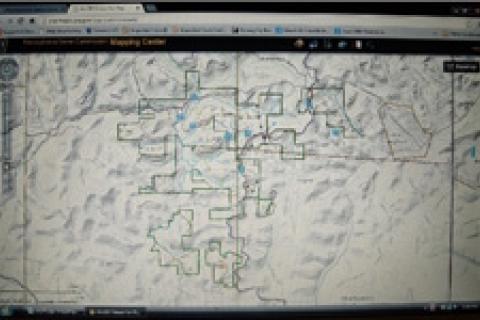
| A GIS-based look at a public hunting area in west central Pennsylvania. |
Recently in my home state of Pennsylvania, the Pennsylvania Game Commission added GIS-based mapping to its online mapping program. Changes are good that the resource agency of your state has done the same, or will in the near future.
The PGC's program is called the Mapping Center. It's only been out a few weeks, and I'm still in the process of learning its many features. But here are some of the basics.
The foundation of the program is the basemap. As its name implies, this is the background map over which various layers of information can be applied. This program has six different basemap options. Three of them are topographic, including the classic USGS topo. Other basemaps show streets and roads. Another basemap is that of imagery — aerial images — like that available on Google Earth and Bing Maps.
Individual basemaps provide specific information to the user. For example, an imagery basemap will show the type of cover — forest, clearings, wetlands, etc. — on the tract being examined. The user can then click to one of the topographic basemaps for a look at the terrain features.
This program also allows the user to apply a range of layers to the basemap. On public hunting areas this includes important information such as the location of parking areas, trails, roads, utility right-of-ways, etc. These layers can be fine-tuned by the user to show only the information he or she desires; this way the map isn't overly cluttered. Once you've customized your map you can save it as a bookmark, so you can return to it the next time you log on to the site; or you can print a hardcopy to take afield.
Another great feature is a tool called "draw and measure." With it you can use the computer mouse to draw a line across the map, measuring the distance from start to finish. So far I've used this tool to help evaluate potential backcountry brook trout streams; more specifically to find out how far certain stream sections are from the nearest road, a case in which farther is better.
If you haven't visited your DNR's website recently, take a moment to do so. Look to see if GIS mapping has been added. It's a powerful and useful planning tool.
- 3033 views