Declination, triangulation, contour lines, scale … with lots of jargon and no “on/off” switch involved, navigation with a map and compass can be daunting for first-timers. But it doesn’t have to be. We’ve distilled what can be a very complicated process down to the basics.
If you’re going to navigate across the ocean or vast expanses of land, you probably want to learn beyond these simple basics. But for most people, these steps will get you into the forest to a given point and, most importantly, back home again.
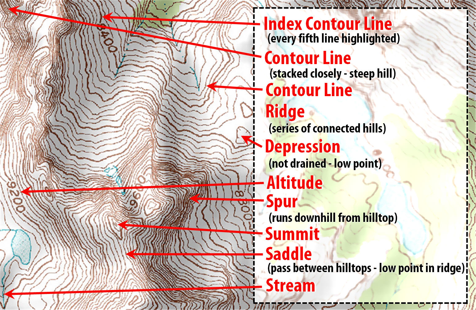
Click for larger view of the topographic map guide.
Orient the Map
This is the most important step, so important that there is an entire sport (orienteering) named after it.
Orient the map page to mimic your environment. This means turn the top of the map (north) to face north in the real world, no matter which direction you’re facing.
For example, if you’re standing on a trail looking north, holding a map horizontally in your hands, the map can be held normally, all text and characters right side up. But if you face south, the map should be read upside down, with the top of the page still facing north. Ditto if you turn to face east or west: Keep the top side of the page always to the north. This technique keeps landforms and features mirrored to their representation on the printed page.
Navigate Compass Confusion
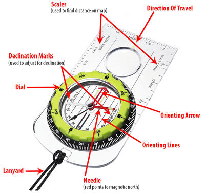 There are lots of features to a compass, but for the vast majority of woodland navigation, follow one simple rule: All you need to know is north.
Modern compasses come loaded with mirrors, rotating base plates, degree markings, spinning dials, and sights. In the vast majority of navigational undertakings, all these accouterments are superfluous. All that matters is north, magnetic north, to be precise.
A quick glance at the compass to see where the needle is pointing — and thus which direction you should orient the map — is the primary.
What are Topographic Lines?
These parallel lines represent hills and valleys on your map. They also present you with some of the easiest-to-follow landmarks in any landscape. With your map oriented to the north (and your known starting point), it is easy to choose routes that follow ridge-lines or valleys, or cross a certain number of ridges or hills, on the way to your end destination.
What are Landmark Attack Points?
A common technique to find a precise location on a map is called an “attack point.” This is an obvious landmark used as a directional aid. For example, if your destination is deep in featureless forest, identify a nearby trail junction, river bend, or other obvious geographic feature. Then restart navigation once you reach the prominent feature (the attack point).
From this established and obvious point, estimate the direction and distance on the map, take a compass bearing, and count your steps.
What is the Declination in a Map
This is simply the difference between true north and magnetic north and it varies from place to place on the Earth’s surface. Topographical maps almost always note the declination in the map scale. While often only a minor deviation from true north, it’s worth noting on each map and making adjustments on a compass for long headings or if the declination is particularly significant.
What Does it Mean to Thumb Your Position on a Map?
To speed travel and map reading, keep a tab of where you are by holding a thumb on your map. This trick allows quick and precise navigation and is a trick often employed by serious orienteers.
As you travel along, move your thumb to the new place on the page to represent your current position. This keeps you aware of your point on the course at all times, speeding navigational decisions and allowing you to always know where you are in the woods. This step really helps when for example, you're in a landscape with repeating features.
- 5766 views